Piri Reis map - antediluvian map of Antarctica without ice
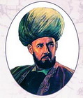
Tourists crossing the Canakkale area through the Dardanelles Strait are usually so carried away by tales of the armies of Xerxes and Alexander of Macedon, who forced the Dardanelles many centuries ago, that they completely ignore the modest bust established on the European side of the strait near the ferry. Few people know that the modest signature "Piri Reis" under the bust connects this place with one of the most intriguing mysteries of history.
In 1929 in one of the ancient Constantinople palaces was found a map dated 1513 year. The map might not have attracted much interest, if not for the image on it of both Americas (one of the earliest in history) and the signature of Turkish admiral Piri Reis. Then, in the 1920s, on the wave of national expansion, it was especially important for the Turks to emphasize the role of the Turkish cartographer in creating one of the earliest maps of America. The map was closely studied, as was the history of its creation. And that's what became known.
In 1513 Admiral of the Turkish Navy Piri Reis completed work on a large map of the world for his geographical atlas "Bahriye". He himself did not travel so much, but, drawing a map, he used about 20 cartographic sources. Of these, eight maps belonged to the time of Ptolemy, some belonged to Alexander of Macedonia, and one, as Piri Reis writes in his book "The Seven Seas," "was recently made incorrect by the name of Colombo." And then the admiral says: "The infidel named Colombo, Genoese, discovered these lands. In the hands of the Colombo named, there was a book in which he read that on the edge of the Western Sea, far in the West, there are beaches and islands. There were found all kinds of metals and precious stones. The above Colombo studied this book for a long time ... Colombo also learned about the passion of the natives for glass decorations from this book and took them with them to be exchanged for gold. "
Let's leave aside for now Columbus and his mysterious book, although the direct indication that he knew where he was sailing is already amazing. Unfortunately, neither this book nor the map of Columbus has reached us. But several sheets of the map from the Atlas "Bahriye" miraculously preserved and in 1811 were published in Europe. But then they did not attach much importance. Only in 1956, when a Turkish naval officer presented maps to the US marine hydrographic administration, US military cartographers conducted a study to confirm or refute what seemed to be impossible: the map depicted the coastline of Antarctica - 300 years before its discovery!
Soon a report was received: "The statement that the bottom of the map shows the coast of Princess Martha [part of] Queen Maud Land in the Antarctic, as well as the Palmer peninsula, has grounds. We found this explanation to be the most logical and, possibly, correct. Geographical details depicted at the bottom of the map are in perfect agreement with seismic data, made through the thickness of the ice cap by the Swedish-British Antarctic expedition in 1949. This means that the coastline was mapped before it was covered with ice. Ice in this area has a thickness of approximately 1.5 km. We have no idea how this data could be obtained at the supposed level of geographic knowledge of 1513 ".
So the Piri Reis map began to reveal its secrets. Here are just some of them
The coastline of Antarctica is precisely indicated on the map!
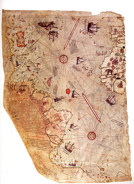
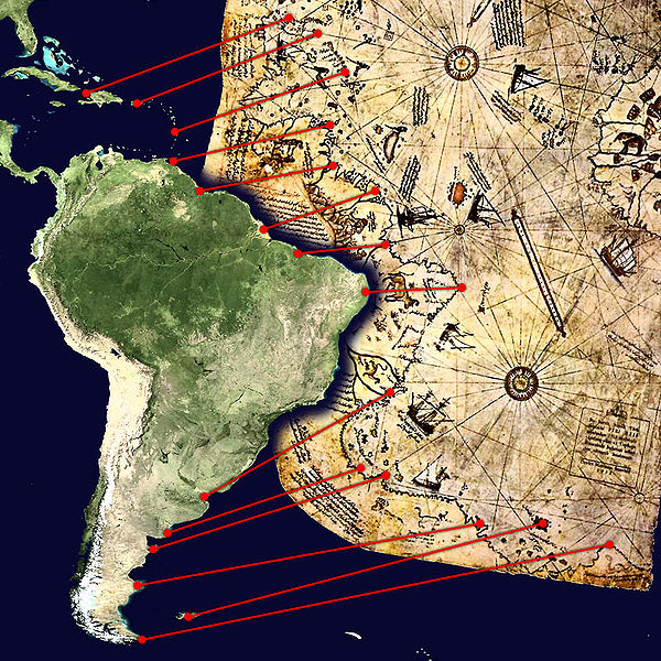
Antarctica as a continent was discovered in 1818, but many cartographers, including Gerard Mercator, before that time believed in the existence of the continent in the far south and put on its maps its alleged outlines. The map of Piri Reis, as already mentioned, accurately displays the coastline of Antarctica - 300 years before its discovery!
But this is not the biggest mystery, especially since several ancient maps are known, including the Mercator map, which, as it turned out, is depicted, and very accurately, Antarctica. Previously, this simply did not pay attention, because the "appearance" of the continent on the map can be highly distorted depending on the cartographic projections used: it is not so easy to project the surface of the globe on the plane. The fact that many ancient maps reproduce with high accuracy not only Antarctica, but also other continents, became known after the calculations done in the middle of the last century, taking into account the different projections used by old cartographers.
But the fact that the map of Piri Reis depicts the coast of Antarctica, not yet covered with ice, is difficult to comprehend! After all, the modern appearance of the coastal line of the southern continent is set by a powerful ice cover that goes far beyond the real land. It turns out that Piri Reis used the sources, which were people who saw Antarctica before glaciation? But this can not be, since these people would have to live millions of years ago! The only explanation of this fact accepted by modern scientists is the theory of the periodic change of the Earth's poles, according to which the last such change could occur about 6,000 years ago, and then Antarctica began to be covered with ice again. That is, we are talking about navigators who lived 6000 years ago and made maps, according to which (as on the map of Piri Reis) were modern ones refined? Incredibly ...
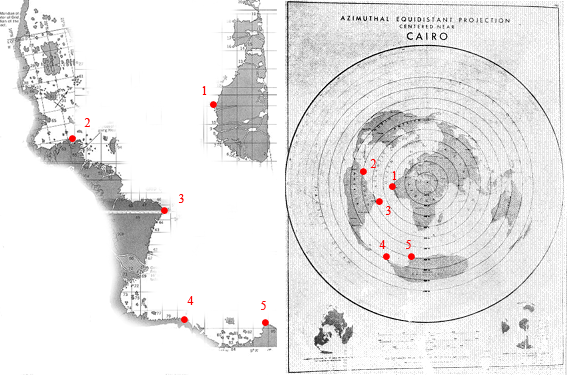
Map is attached to Cairo
It is interesting that the Piri Reis map gives an answer to the question of where these ancient seafarers lived. (Or are they not navigators if they used other means of transportation?) The fact is that a professional cartographer, by studying the ancient map and comparing it with modern maps, can determine what kind of projection the map maker used. And when the map of Piri Reis was compared with the modern one, made up in a polar equal-sized projection, they found almost complete similarity. In particular, the map of the Turkish admiral of the 16th century literally repeats the map compiled by the US Air Force during the Great Patriotic War.
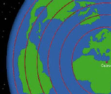
But the map, drawn up in a polar equal-area projection, should have a center. In the case of the American map, it was Cairo, where during the war there was an American military base. And from this, as shown by the Chicago scholar Charles Hapgood, who thoroughly studied the map of Piri Reis, it follows directly that the center of the ancient map, which became the prototype of the map of the admiral, was there, in Cairo, or its environs. That is, the ancient cartographers were Egyptians who lived in Memphis, or their more ancient ancestors, which made this place a reference point.
Mathematical apparatus of cartographers
But whoever they were, they skillfully owned their craft. As soon as the researchers began to study the fragments of the map of the Turkish admiral that survived to us, they faced the question of the authorship of its original source. The Piri Reis map is a so-called portalan, a naval map that allows to build "lines between ports", that is, to navigate between port cities. In the XV-XVI centuries such maps were much more perfect than land maps, but, as one of the leading scientists in this field, AE Nordenskiold, they did not develop. That is, maps of the XV century were of the same quality as the maps of the XIV century. This, from his point of view, indicates that the skill of cartographers was not acquired, but borrowed, that is, in simple terms, they simply redrawn more ancient maps, which in itself is natural.
But what does not fit into the head is the accuracy of the constructions and the mathematical apparatus, without which these constructions are simply impossible to fulfill. I will give just a few facts.
It is known that for the construction of a geographical map, that is, the mapping of a sphere on a plane, it is necessary to know the dimensions of this sphere, that is, the Earth. The circumference of the globe managed to measure Eratosthenes even in ancient times, but did it with great error. Until the XV century, no one specified these data. However, a thorough study of the coordinates of objects on the Piri map indicates that the Earth's dimensions are taken into account without error, that is, at the disposal of the compilers of the map there was more accurate information about our planet (not to mention that they represented it as a sphere). Researchers of the Turkish map also convincingly showed that the compilers of the mysterious ancient source had trigonometry (the Reis map is drawn using a planar geometry where the latitudes and longitudes are at right angles, but it was copied from a map with spherical trigonometry!) Ancient cartographers not only knew that the Earth There is a ball, but also calculated the length of the equator with an accuracy of about 100 km!) And cartographic projections that were not known to Eratosthenes or even Ptolemy, and they theoretically could use the ancient maps stored in the Alexandria library. That is, the source of the card is definitely more ancient.
The map shows both America

The map of Piri Reis is one of the first on which both Americas are indicated. It was compiled 21 years after the sailing of Columbus and the "official" discovery of America. And it is marked not only by the exact coastline, but also by the rivers, and even by the Andes. And this despite the fact that Columbus himself did not map America, having reached only the Caribbean islands!
The mouths of some rivers, in particular Orinoco, on the map of Piri Reis are shown with an "error": delta rivers are not indicated. However, this speaks rather not about an error, but about the expansion of deltas that has occurred over time, as it was with the Tigris and the Euphrates in Mesopotamia in the last 3500 years.
Columbus knew where he was swimming
Piri Reis claimed that Columbus knew very well where he was sailing, thanks to a book that fell into his hands. The fact that the wife of Columbus was the daughter of the Grand Master, who had already changed the name of the Knights Templar, possessed considerable archives of ancient books and maps, points to a possible way of acquiring a mysterious book (to date, much has been written about the Templar fleet and the great likelihood of their regular voyages in America).
There are many facts indirectly confirming that Columbus owned one of the maps that served as a source for the Piri Reis map. For example, Columbus did not stop the ships at night, as was customary due to fear of flying into the reefs in unknown waters, but walked under all sails, as if knowing for sure that there would be no obstacles. When the revolt began on the ships because the promised land did not show up, he managed to convince the sailors to suffer another 1000 miles and was not mistaken - exactly 1000 miles later the long-awaited shore appeared. Columbus carried with him a stock of glass ornaments, hoping to exchange them for gold from the Indians, as recommended in his book. Finally, each ship had a sealed packet with instructions on what to do if the ships lost sight of each other during the storm. In short, the pioneer of America knew very well that he was not the first.
The Piri Reis map is not the only one
And the map of the Turkish admiral, the source for which were served, including the maps of Columbus, is not the only one of its kind. If you aim, as Charles Hapgood did, to compare the images of Antarctica on several maps drawn up before its "official" discovery, there will be no doubt about the existence of their common source. Hapgood scrupulously compared the maps of Piri, Aranteus Finaus, Hadji Ahmed and Mercator, created at different times and independently of each other, and determined that they all used the same unknown source, which allowed the polar continent to be depicted with great certainty long before its discovery.
Most likely, we no longer know for sure who created this source and when. But its existence, convincingly proved by the researchers of the map of the Turkish admiral, testifies to the existence of some ancient civilization with a level of scientific knowledge comparable to the modern one, at least in the field of geography (the Piri map, as already mentioned, made it possible to clarify some modern maps). And this calls into question the hypothesis of the gradual linear progress of mankind in general and of science in particular. There is a feeling that the greatest knowledge of nature, as if obeying an unknown law, at a certain stage becomes available to mankind, then to be lost and ... to be reborn again when the time comes. And who knows how many discoveries will conceal the next find?


Comments
Commenting on, remember that the content and tone of your message can hurt the feelings of real people, show respect and tolerance to your interlocutors even if you do not share their opinion, your behavior in the conditions of freedom of expression and anonymity provided by the Internet, changes Not only virtual, but also the real world. All comments are hidden from the index, spam is controlled.