
| |
Map of kyiv (the main highways of the capital of Ukraine g.Kiev, the scheme of transit passage)
|
Map of Kerch. Autonomous Republic of Crimea, the scheme of travel through the city of Kerch
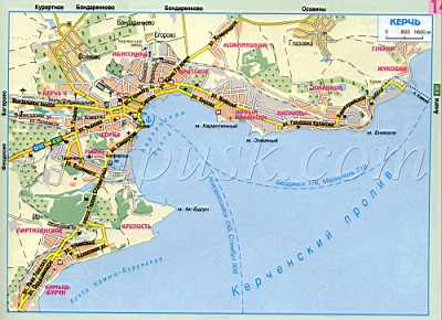 |
Map of Kerch (Crimea, Kerch)
This port city was once big, very beautiful and important. It occupies a lot of place on the map, because it is scattered almost 60 kilometers along the Kerch Peninsula - the eastern extremity of the Crimea. The peninsula itself is 3000 square meters. Kilometers separates the two seas, and the Kerch Strait residents call the 'third sea'. Through it there are large sea vessels, but for this purpose it was specially necessary to deepen the channel. In the past, the strait was so shallow that, on its bottom, from the Crimean coast to the Caucasus, the herds of cows were driven. The Greeks called this Cimmerian Bosporus Strait. Bosporus in Greek - Bull Wander. Its length is 40 kilometers, width is from 4 to 15 kilometers. The Kerch Strait connects the rivers of northern Europe with the South Seas; On it passed the famous in the history way from the Varangians to the Greeks and the Great Silk Road, the most important for the merchants of the ancient world and the Middle Ages.
There are five mountain ridges on the Kerch Peninsula. One of them, the central one, forms an elevation, around which a modern city is built. It is the Mithridates mountain, named after the legendary ruler of the Bosporan state, Mithradates VI Evpator. In the valleys between the mountain ranges fertile land, the inhabitants of the Bosporus grew wheat on it and sold it to Greece.
In Kerch special microclimate, it makes it unlike the rest of the Crimea. Around the city, iron ore, gas and oil deposits, curative hydrogen sulfide springs have been found. There are several dozens of
Yawning volcanoes; One of them, Jau-Tepe, is included in the World catalog of mud volcanoes, and in the Bulganak area a whole comparative field has been collected.
On the coast there are good sandy beaches, however, few rivers. Through the city, the river Pantikapa flows (in Old Iranian - 'fish course'). In 1944, on its shores, a seaside army was established, which ousted the fascists from the Crimea. Since then, this river is called Primorskaya.
WHAT IS TRUTH, AND WHAT IS A MYTH?
The inhabitants of Panticapaeum were the first in Europe to learn how to smelt iron, and in the 5th century BC, Herodotus mentioned it. He also noted that the Cimmerians live in the eastern part of the Kerch peninsula.
The poet Maximilian Voloshin was the first to call Cimmeri all of the Eastern Crimea, including his beloved Koktebel. This area is mythical. About it you can read in ancient and important for world history sources that tell about the Trojan War, which, according to myths, was in the 12th century BC. This war was told to the world by Homer in the Iliad. This myth is cruel, but poetic: the war broke out because of the beautiful Helen, whose love was claimed by the son of King Troy Paris and the Tsar of Sparta Menelai. Perhaps, the beauty turned out to be a fateful occasion for hot, proud southerners, but today schoolchildren understand that the real causes of wars are almost always connected with the economy. These sinister economic roots are always visible in ancient history. Here, in the Eastern Crimea, the Cimmerians lived; Perhaps they grew grain and sold it to distant Hellas. However, Troy stood in the way of the laden merchant triremes and penters.
Detailed road map download for free


Comments
Commenting on, remember that the content and tone of your message can hurt the feelings of real people, show respect and tolerance to your interlocutors even if you do not share their opinion, your behavior in the conditions of freedom of expression and anonymity provided by the Internet, changes Not only virtual, but also the real world. All comments are hidden from the index, spam is controlled.