
Ecological maps of Ukraine
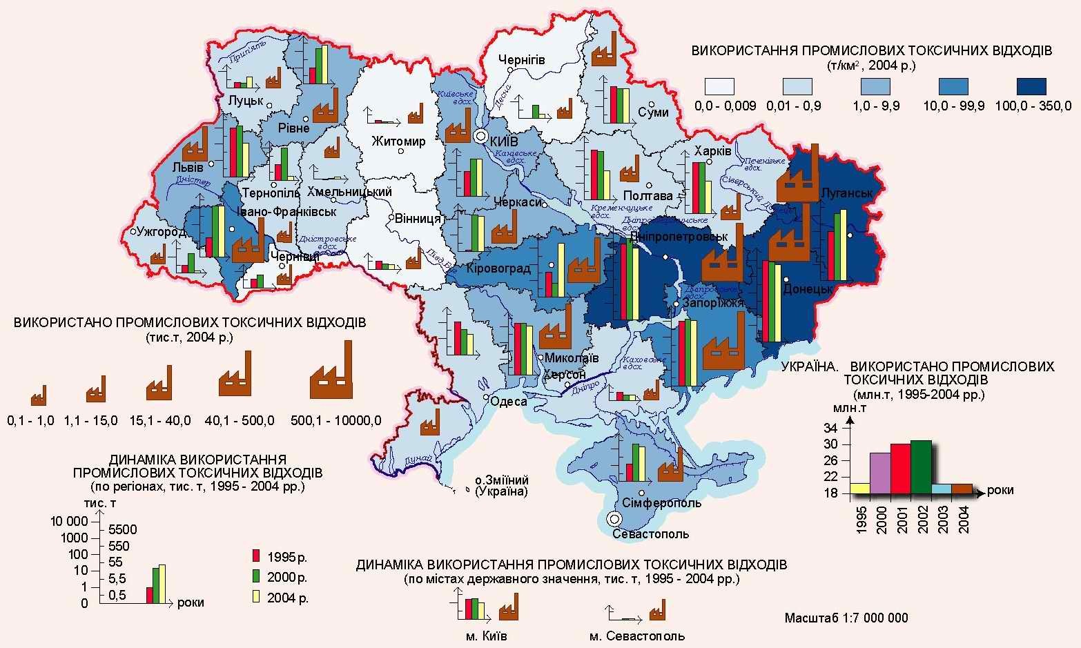
Use of industrial toxic waste in Ukraine
Map of the use of industrial toxic waste in Ukraine.
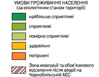
Map of living conditions of the population
Map of living conditions of the population on the territory of Ukraine.
In Ukraine, temperate continental climate. Also on the territory of Uraina - the best soils on the planet - chernozems. This combination allows you to grow a full range of crops. On the territory of Ukraine, favorable conditions for the population to live. The north-west movement of air masses prevails in Ukraine. During the year, over 46 cyclones and 37 anticyclones pass over Ukraine.
The river network of Ukraine (totals approximately 72 thousand rivers), it is rather dense and branched (0.25 km / km2). The rivers belong mainly to the basin of the Black Sea, the Sea of Azov and partially to the Baltic.
Ecological and geochemical conditions of landscapes of Ukraine under the powerful influence of technogenic activity have changed significantly in recent times ...
The climatic conditions of Ukraine are an important natural resource. Favorable climatic conditions, rich in flora and fauna landscapes are the most important recreational resource, and there are still many such regions in Ukraine
Map of anthropogenic changes in terrain
Map of anthropogenic changes in the relief of Ukraine.
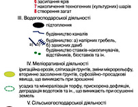
Anthropogenic relief is called a relief altered or created by human activities. Anthropogenic forms of relief for the first time people began to change even at a time when hunting tribes began digging pits for catching animals, caves, etc. At the cattle-breeding farm, foci of erosion and scattering of sand due to skotosboy began to appear. The greatest distribution in Ukraine and all over the world, anthropogenic relief received with the development of agriculture. There are spontaneously arising anthropogenic relief and deliberately created anthropogenic relief. Elements of the first - mainly "weeds of relief", formed as a result of improper conduct of agriculture and forestry, mining workings, construction, road construction: ravines, cones of removal, shallows, subsidence, mobile sands. In a number of countries, the development of these forms radically changed the face of the area, worsened the water regime, reduced the arable land and reduced their fertility.
Conscious transformation of the relief is made during reclamation (terracing and sloping of slopes, construction of drainage and irrigation, networks, field planning), construction (embankments, excavations, canals, dams), etc. Anthropogenic relief also includes inevitable, though harmful, forms: quarries, dumps, etc. Anthropogenic relief is a component of the anthropogenic landscape.
Map of the state of modern landscapes
Map of the state of modern landscapes of Ukraine.
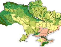
Geochemical landscapes of Ukraine are represented by landscapes of four bioclimatic zones: forest-wood landscapes of the woodland in the north, forest-steppe landscapes of Polissya, Volyn-Podolsky Upland and Pridneprovskaya Plain; Landscapes of the northern steppes of the slopes of the Volyn-Podolsky and Central Russian Uplands; Landscapes of the southern steppes, developed on the area of the Black Sea lowland and the Prisivash depression; Forest meadow mountain landscapes of the Carpathian and Crimean mountains and foothill plains.
The development of mining and processing industries in Ukraine, as well as intensive agro-industrial use of territories, leads to significant and often irreversible changes in the geochemical and ecological conditions of landscapes.
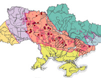
The territory of Ukraine is characterized by the following landscape zones, which are determined:
- High self-cleaning ability and low degree of dirt. This includes the Transcarpathian region, the southwestern part of the Lviv, Ivano-Frankivsk regions (except for the northeast), the south-western part of the Chernivtsi region and the mountainous Crimea.
- The average degree of self-cleaning and contamination. This includes the south of the Zhytomyr region, the south-western part of the Kiev, north and north-east Vinnytsia, Cherkassy and part of the Dnepropetrovsk region, the south of Donetsk and Zaporozhye regions.
- Low self-cleaning ability and low pollution: the north of the Lviv region, the south of Volyn, Ternopil, Nikolaev, Kharkov, the south of Vinnytsia, the north of Odessa, the north of Kharkov, Lugansk regions and Crimea, and the low level of self-cleaning and high contamination of industry with Dnipropetrovsk, Zaporozhye regions.
- Territories, in which the accumulation of industrial pollution predominates, is a large part of the Kiev, Chernigov, Sumy, Poltava, eastern Dnepropetrovsk, Donetsk, Zaporozhye regions and the south of the Lugansk region.
- Zones Polesye, Kiev, Chernigov, Cherkassy regions, the zone of traces of the Chernobyl accident, which belong to the variable zones of accumulation and self-purification.
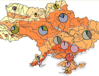
Map of the natural radioactivity of the territory
Map of natural radioactivity of the territory of Ukraine.
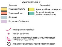
Natural radioactivity, as not sadly exists for billions of years, it is present literally everywhere. Ionizing radiation existed on Earth long before the birth of life on it and is present in space. And Ukraine is not an exception. Radioactive materials have been a part of the Earth since its birth. Any person is radioactive: in the tissues of the human body one of the main sources of natural radiation is potassium-40 and rubidium-87, and there is no way to get rid of them.
Modern people spend up to 80% of the time in rooms - at home or at work, where they receive the main dose of radiation: although buildings protect from radiation from outside, the building materials from which they are built contain natural radioactivity. A significant contribution to human irradiation is made by radon and the products of its decay.
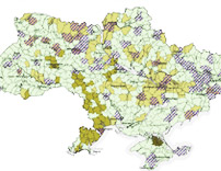
Map of especially valuable soils of Ukraine
Map of especially valuable soils of Ukraine.
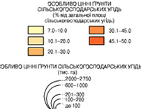
Fertile soils of Ukraine are the most important resource potential of this country. The most fertile are soils with a humus content of 3 to 7% and a thickness of the humus layer of about 1 meter (there are about 10% of the territory in Ukraine).
The most valuable lands include: chernozems, unerodified, non-lobed on loess rocks; Meadow-chernozem, non-salty, non-solonetsous loamy soils; Dark gray podzolized and chernozems podzolized on loess and clayey; Brown mountain-forest and soddy-brown earth deep and medium deep; Sod-podzolic loamy soils; Peat bogs with a depth of occurrence of peat more than one meter and drained, regardless of depth; Brown soils of the Southern coast of Crimea; Sod deep soils of Transcarpathia; Lands of experimental fields of scientific research institutions and educational institutions; Lands of the nature reserve fund; Lands of historical and cultural significance.
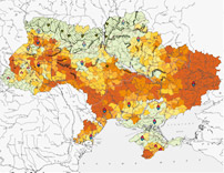
Map of soil contamination with residues of pesticides and heavy metals
Map of soil contamination with residues of pesticides and heavy metals in Ukraine.
The soils of Ukraine are polluted with various chemical substances, pesticides, agricultural wastes, industrial production and domestic utilities. Chemical compounds that enter the soil accumulate and lead to a gradual change in the chemical and physical properties of the soil, reduce the number of living organisms, and worsen its fertility.
Pollution of soils and disruption of the normal cycle of substances occurs as a result of the underdosed application of mineral fertilizers and pesticides. In a number of agricultural sectors, pesticides are used in large quantities to protect plants and control weeds. Their annual application, often several times a season, leads to their accumulation in the soil and its poisoning. In the soils, metal compounds, for example, iron, mercury, lead, copper, etc. accumulate. Soil contamination in Ukraine.
Soil degradation map of Ukraine
Map of soil degradation in Ukraine.
Soil is the keeper of fertility and life on Earth. It takes 100 years to form a layer 1 cm thick. But it can be lost in just one season of the thoughtless exploitation of the land by man. According to geologists, before the man began to engage in agricultural activities, the rivers annually carried to the ocean 9 billion tons of soil. With human assistance, this figure has increased to 25 billion tons per year. The phenomenon of soil erosion is becoming more and more dangerous, as fertile soils on the planet are becoming less and it is vitally important to preserve at least those that are at the moment, not to allow the disappearance of this single layer of the earth's lithosphere, on which plants can grow.
Under natural conditions, there are several reasons for soil erosion (weathering and washing out of the upper fertile layer), which are even more intensified by man. Millions of hectares of soil are lost due to:
- Industrialization, construction of buildings and roads;
- Wrong exploitation, aimed at maximally squeezing out of the earth all that is possible, and then throw an unusable wasteland;
- Chemical and industrial pollution;
- Deforestation, which protect the soil from weathering and washing out;
- The construction of the dams of the GES, before which the bogging takes place, and after which - the drying of the soil;
- Extraction from the depths of the earth tons of rocks, in which, almost the entire table of Mendeleyev, including radioactive substances.
Map of emissions of pollutants into the atmospheric air by settlements
Map of emissions of pollutants into the atmospheric air of urban settlements of Ukraine.
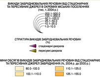
The most polluting nature is energy facilities, primarily the CHPP and GRES. Absorbing a huge amount of oil products, gas and coal, they throw millions of cubic meters of harmful gases, aerosols, soot into the atmosphere, occupy hundreds of hectares of land with slag and ash.
Another source of pollution of nature of Ukraine is transport - automobile, air, water, railway. In all large cities of Ukraine, the mass fraction of air pollution from motor vehicles has recently been 70-90% of the total mass of pollution.
All sources related to the specific territory of the enterprise are stationary sources of emission of harmful (polluting) substances into the atmospheric air.
Stationary sources of emission of harmful (polluting) substances into the atmospheric air are divided into two types:
- Sources with organized emission;
- Sources with fugitive emissions.
The most common form of these terms is "organized source" and "unorganized source".
An organized ejection is understood as an outflow that enters the atmosphere through specially constructed flues, ducts and pipes; Unorganized emission refers to the release entering the atmosphere in the form of non-directional gas flows as a result of a breach of the tightness of the equipment, lack of or unsatisfactory performance.
Map of the acidity of atmospheric precipitation in Ukraine
Map of the acidity of atmospheric precipitation in Ukraine.
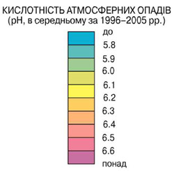
One of the most acute global problems of the present and the foreseeable future is the problem of the increasing acidity of atmospheric precipitation and soil cover. The areas of acid soils do not know droughts, but their natural fertility is lowered and unstable; They are rapidly depleted and the yields on them are low.
Acid rain causes not only acidification of surface waters and upper horizons of soils. Acidity with downward flow of water extends to the entire soil profile and causes significant acidification of groundwater. Acid rain occurs as a result of human economic activity, accompanied by the emission of colossal amounts of sulfur oxides, nitrogen, carbon.
These oxides are transported to the atmosphere over long distances, interact with water and turn into solutions of a mixture of sulfur, sulfuric, nitrogenous, nitric and carbonic acids, which fall out as "acid rains" on land interacting with plants, soils, and waters.
The main sources in the atmosphere are burning of oil shale, oil, coal, gas in the industry, in agriculture, in everyday life. Human economic activity has almost doubled the intake of sulfur, nitrogen, hydrogen sulphide and carbon monoxide into the atmosphere. Naturally, this affected the increase in the acidity of atmospheric precipitation, ground and groundwater. To solve this problem, it is necessary to increase the volume of systematic representative measurements of compounds of air pollutants in large areas.
Map of surface water pollution in Ukraine
Map of pollution of surface waters of Ukraine.
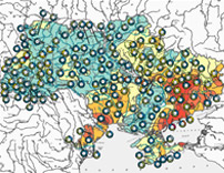
The quality of surface water depends on the combination of climatic and geological factors.
The main climatic factor is the amount and frequency of precipitation, as well as the ecological situation in the region. Falling precipitation carries a certain amount of undissolved particles, such as dust, volcanic ash, plant pollen, bacteria, fungal spores, and sometimes even larger microorganisms. The ocean is the source of various salts dissolved in rainwater. It can detect ions of chloride, sulfate, sodium, magnesium, calcium and potassium. Industrial emissions to the atmosphere also "enrich" the chemical palette, mainly due to organic solvents and nitrogen and sulfur oxides, which are the cause of the precipitation of "acid rain". Contribute to their contribution and chemicals used in agriculture.
The structure of the river bed is one of the geological factors. If the channel is formed by calcareous rocks, then the water in the river is usually transparent and stiff. If the channel is made of impermeable rocks, for example granite, then the water will be soft but cloudy due to a large number of suspended particles of organic and inorganic origin.
In general, surface waters are characterized by relative softness, high content of organic matter.
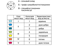
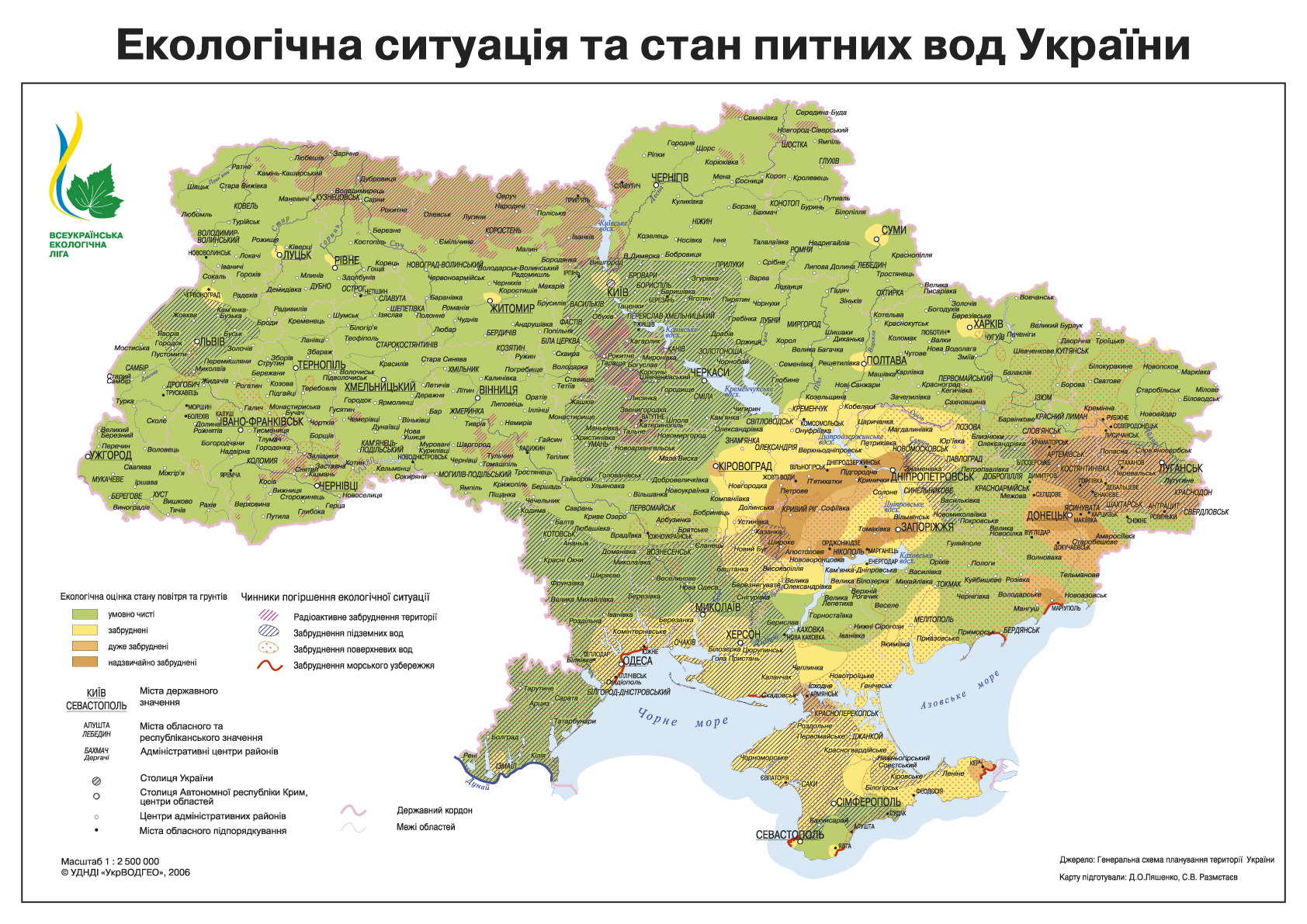
Ecological situation and condition of drinking water in Ukraine.
The map was developed and provided by the "ALL-UKRAINIAN ECOLOGICAL LEAGUE".

Comments
When commenting on, remember that the content and tone of your message can hurt the feelings of real people, show respect and tolerance to your interlocutors even if you do not share their opinion, your behavior in the conditions of freedom of expression and anonymity provided by the Internet, changes Not only virtual, but also the real world. All comments are hidden from the index, spam is controlled.